Standard Places
Originally posted here.
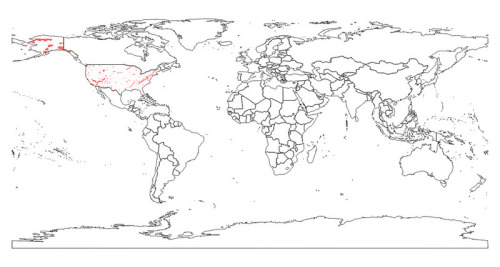
Down the road, we'd like to come up with some cool new map-based visualizations that incorporate iNat places. For example, here's a map of US counties color coded by number of observations. Hover over to see the most observed species in a county:
But to do this, we need to have a somewhat standardized subset of places to work with. Over the years, iNaturalist has amassed a lot of places. Some of these were uploaded by the iNat team and some of them were individually created by community members. This means there’s alot of duplication and varying degrees of quality represented. Without impacting the ability for the community to create, share, and use their own places, we wanted to complement these ‘Community Curated’ places with a more standardized set of places we can for the most part all agree on (like US counties)
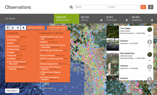
As a result, we’ve cleaned up a subset of places that we’re calling 'Standard’ places. Some of you may have noticed the 'Standard'and 'Community Curated’ sections in the 'Places of Interest’ window on the new Observations page:
At the moment, this Standard set contains 3 types of places:
1. Administrative Units ('countries’, 'states’, and 'counties’)
The world is typically divided in to a heirarchy of Administrative Units. In the United States, there’s the country at the top (level 0), then the 50 states (level 1), and then around 3,000 counties (level 2). In other countries level 1 units have other names, like regions or provinces. In some countries things are further divided into increasingly small administrative units, but we stopped at these three levels.
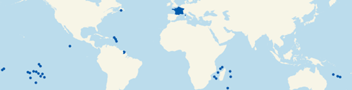
Countries are defined by distinct ISO country codes. The exact number of countries fluctuates from year to year, but is around 250. Note that there are more countries than the ~200 Sovereign States. For example, the Sovereign State of France includes many territories around the world. But the ISO country of France only includes what we typically think of as France in Europe. The Caribbean territory of St. Martin for example, is part of the Soverign State of France but usually gets its own ISO country code. Here’s a map from NaturalEarth showing the Sovereign State of France:
For the most part, we’re using the Global Administrative Areas Database (GADM - fondly pronounced 'gaddamn’) produced by the University of California as our source for admin level 0, 1, and 2 places in the iNat Standard set. We used GADM v.2.8 which is the current version at the time of this writing. We did swap out the US data in GADM with the the official US Census Tiger data and the Mexican data in GADM with the official Mexican INEGI data because they differed slightly and constiuents within the iNat community felt strongly that we integrated these official government versions.
The US TIGER data comes with a wonderful 0.05 degree coastal buffer around each of the boundaries. We like this because:
- It means that observations in low tide areas or otherwise right on the boundary between land and sea are decisively included within the boundary (ie avoids questions like “Why are only half of the observations from my tide-pool trip counted within California?”).
- Buffering the coastline removes potentially Mandelbrotian complexity from these boundaries which makes things faster.
- The buffer makes the display of these boundaries clean an consistent on our maps.
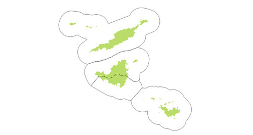
Because the GADM data and the INEGI data lack this buffer (GADM for example tracks the coastline to 15 meter precision which makes for very complex and intractable boundaries), we copied the TIGER buffering algorithm and applied it to all other administrative units in our standard set. For Example, here’s how the buffered country units (black outlines) look compared to the raw GADM units (green) in the Anguilla bank which includes St. Martin (half of the island of St. Martin is Dutch and the other half is French):
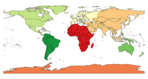
Here’s what the finished 253 Level 0 (countries) look like:
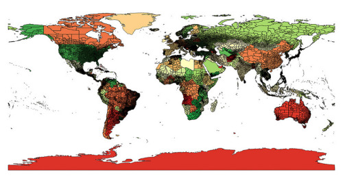
Here’s what the finished ~3,000 Level 1 (states) look like:
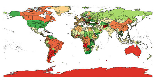
Here’s what the finished ~40,000 Level 2 (counties) look like:
2. Continents
We also included continents in the standard set due to demand from the iNat community. Continents aren’t administrative units, and countries don’t fit nicely within them. For example, Russia straddles Asia and Europe. The number and extent of continents is also controversial, but we’re following the widely used 7-continent model. We produced the boundaries by taking the union of the country boundaries described above to produce a map of 'land’ including the 0.05 degree coastal buffer and then sliced it into the 7 distinct continents. Here’s how they look.
3. Partner places
In 2016, iNaturalist worked with the US National Park Service to help facilitate over 100 Bioblitzes in National Parks. Because the park service wanted a way to make sure the representation of their ~430 National Park Units on iNaturalist was relatively standardized, we’ve included these 429 National Park units as part of the Standard set. We realize there are many other really good sets of parks units represented among iNaturalist places (e.g. the Vermont State Parks) and, and down the road would like to get these incorporated into the Standard set or come up with better tools for the community to curate these places
If you notice anything funky with these places, please let us know. We will also work in the next few weeks to further document this Standard place set, how it was created, and how you can help maintain and potentially expand it.


